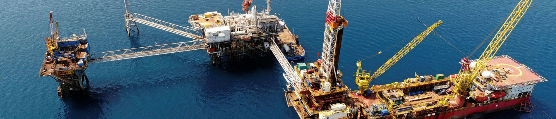
EXPLORATION

EXPLORATION

HEREMA has been mandated with accelerating the development of Greece’s upstream sector with a particular focus on natural gas. Successful discoveries will boost economic development, bolster energy security, and support energy demand as we transition to net zero by 2050.

The duration of the exploration phase is limited to seven years in land areas and eight years in maritime areas (Law 2289/1995). This period can be extended by HEREMA, upon the request of the lessee(s), for a period no longer than half of the initial term as long as certain conditions are met. The length of the exploration phase may also be extended following a decision by the Ministerial Council.

A BLUEPRINT FOR SUCCESS

In view of the crucial role of natural gas in ensuring energy security and enabling our transition to a net zero future, in April 2022 the Greek government mandated HEREMA with the acceleration of upstream development. Ambitious goals were laid out, while hydrocarbon exploration and production projects were elevated to projects of national importance.

ACTIVE EXPLORATION CONCESSIONS

Use CTRL + Scroll to zoom the map

Out of Greece’s eight active concessions,
six are in the exploration phase.

Select to discover:

Located in the Ionian Sea, 30 km west of Corfu Island, the western boundary of Block 2 is adjacent to the Greek-Italian border. Water depths range from 500 m to 1,500 m with the area forming part of the Apulian platform geological unit. The existence of a proven petroleum system is Western Greece (West Katakolon) and the Adriatic Sea generates a clear interest in this region.

In 2022, 2244 sq. km. of 3D seismic data were acquired.

Ionian Block is located in the central and western areas of North Ionian Sea. It covers part of the Apulian platform and the Pre-Apulian zone. Oil and gas discoveries offshore Albania and Italy serve as valid indicators of a working petroleum system in the Ionian Block.

The hydrocarbon charge in this area is characterised by the proven hydrocarbon generation from late triassic source rocks (sabkha or lagoonal environments), early liassic intra-platform basin deposits, and lacustrine organic-rich facies offshore the Apulian platform.

In early 2022, a 2D seismic survey was undertaken in the Ionian Block covering approximately 1,600 l-km, and in Q4 2022 3D seismic data covering 1150 sq.km. were acquired.

In July 2023, the Operator entered into the second Exploration Phase, to finalize the processing and interpretation of newly acquired data, and mature the prospectivity of the exploration area.

Block 10 lies offshore the western Peloponnese in the Kyparissiakos gulf area. Water depths range between 500 m to 2,500 m. The existence of a proven petroleum system in the adjacent block, West Katakolon, coupled with the abundance of oil seeps and gas escapes in the region generate a clear interest in this block.

Moreover, several oil and gas fields have been discovered in Albania, which belong to the same fold and thrust belt with similar geological characteristics.

In early 2022, a 2D seismic survey was undertaken in Block 10 covering approximately 1,200 l-km, and in Q4 2022 3D seismic data covering 2430 sq.km. were acquired.

In July 2023, the Operator entered into the second Exploration Phase, to finalize the processing and interpretation of newly acquired data, and mature the prospectivity of the exploration area.

Located offshore the island of Crete, multichannel seismic data acquired in 2012 indicated the existence of carbonate structures analogous to recent gas discoveries made in the Eastern Mediterranean (Egypt and Cyprus).

In early 2023, a 2D seismic survey was undertaken covering approximately 4,490 km.

Located offshore the island of Crete, multichannel seismic data acquired in 2012 indicated the existence of carbonate structures analogous to recent gas discoveries made in the Eastern Mediterranean (Egypt and Cyprus).

In early 2023, a 2D seismic survey was undertaken covering approximately 7,789 km, and in Q1 2024 a 3D high-resolution survey was acquired, covering 900 sq.km.

In October 2024, the Joint Venture entered into the second Exploration Phase, to finalize the processing and interpretation of newly acquired data, and mature to prospectivity of the exploration area.

An onshore block in Western Greece, the Ioannina block is relatively underexplored and is considered the southern-most extension of the greater peri-Adriatic Basin, where oil and gas discoveries have been made in Albania, Italy, and Croatia. Over 10 billion barrels of oil and 30 TCF of gas have been discovered throughout this region.

In 2019 a 2D seismic survey was undertaken in the Ioannina Block covering 400 km. The Operator is currently in the second exploration phase which entails the drilling of an exploration well.

Key Facts

Licensees
Energean Hellas Ltd. (75% and Operator) and HELLENiQ Upstream West Kerkyra Single Member S.A. (25%)
Preliminary assessment of hydrocarbon potential
Oil and gas
Useful Links
Stage
First exploration phase
Block Size
2,422.1 Km2
Water Depth
500 m to 1,500 m
Seismic Data
1,292 km (2D) and 2244 sq. km. (3D)

Key Facts

Licensees
HELLENiQ Upstream Ionian Single Member S.A. (100%)
Preliminary assessment of hydrocarbon potential
Oil and gas
Useful Links
Stage
Second exploration phase
Block Size
5,001.78 Km2
Water Depth
500 m to 2,800 m
Seismic Data
5,607 km (2D) and 1150 sq. km. (3D)

Key Facts

Licensees
HELLENiQ Upstream Kyparissiakos Gulf Single Member S.A. (100%)
Preliminary assessment of hydrocarbon potential
Oil and gas
Useful Links
Stage
Second exploration phase
Block Size
2,735.79 Km2
Water Depth
500 m to 2,500 m
Seismic Data
4,178 km (2D) and 2430 sq. km. (3D)

Key Facts

Licensees
ExxonMobil Exploration & Production Greece B.V. (70% and operator) and HELLENiQ Upstream West Crete Single Member S.A. (30%)
Preliminary assessment of hydrocarbon potential
Natural gas
Useful Links
Stage
First exploration phase
Block Size
20,058.4 Km2
Water Depth
2,000 m to 4,850 m
Seismic Data
1,003 + 4,490 km = 5,493 km (2D)

Key Facts

Licensees
ExxonMobil Exploration & Production Greece B.V. (70% and operator) and HELLENiQ Upstream SouthWest Crete Single Member S.A. (30%)
Preliminary assessment of hydrocarbon potential
Natural gas
Useful Links
Stage
First exploration phase
Block Size
15,583.80 Km2
Water Depth
2,080 m to 4,500 m
Seismic Data
1,334 + 7,789 km = 9,123 km (2D), 900 sq. km (3D)

Key Facts

Licensees
Energean Oil & Gas (100%)
Preliminary assessment of hydrocarbon potential
Oil and gas
Stage
Second exploration phase
Block Size
2,237.59 Km2
Seismic Data
2,403 km (2D)